The Excavations
The LMU Munich team's excavations started in spring 2015. Since then two excavation seasons were carried out in autumn 2016 and 2017. During these three field campaigns, the Shamlu Archaeological Mission has opened six areas of excavations (Sectors 1–6), which are distributed over the main mound and the eastern lower town. Excavations in these sectors have produced much information not only on the stratigraphy of the site, but also on the architecture , economy, social structures and consumption habits of the ancient inhabitants of Gird-i Shamlu.
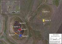
The main mound - Sectors 1, 3, 4, 5 & 6
Sector 1 lies on the highest part of the mound. The main focus of the investigations there lies on the mid-2nd Millennium BCE and older remains to retrieve information on contexts associated with the so called Shamlu pottery. The latter was first discovered, identified and described by Kadhim al-Janabi of the General Directorate of Antiquities, Baghdad, who carried out short salvage excavations at the site in 1960/1 (see below). Levels containing architectural structures associated with significant amounts of Shamlu pottery have been reached in the center of Sector 1. Since the inhabitants appear to have thoroughly cleaned their houses before they left, excavations in Sector 1 have so far revealed only few fragmented vessels and broken bronze tools. However, according to results of the earlier Iraqi excavations, richer and better-preserved contexts are to be expected in deeper levels, which will be reached in the coming seasons.
Apart from the mid-2nd millennium BCE remains, excavations in Sector 1 have also revealed Late Bronze and Iron Age levels. However, modern looting pits as well as a multi-phased Medieval and modern Islamic graveyard has disturbed these levels severely. Therefore, our understanding of these periods at Gird-i Shamlu is still quite limited.
Sector 3 lies at the southern base of the main mound and extends southwards into the Early Bronze Age lower town. Excavations here have exposed remains of mud-brick buildings which featured fire installations, which were probably related to food processing. Contexts range from the beginning to the last third of the 3rd millennium BCE with finds of scarlet ware and undecorated pottery, terracotta figurines and lithic tools. The early 3rd millennium BCE settlement was destroyed by a fire in this part of the site.
Sector 4 is situated at the southwestern base of the main mound in an area that is colloquially referred to as "Shamlu beach". This area is highly affected by water erosion caused by the Darband-i Khan Lake, which extends as far as Gird-i Shamlu when it reaches its annual maximum water level during winter and spring. In 2016, Gird-i Shamlu was completely surrounded with water for the first time since 1974. Only two weeks before the start of the excavation season, the water retreated, thus exposing several mud-brick structures. Cleaning and excavating the visible mud-brick features revealed parts of a mid-4th millennium BCE occupation at the site. The chalcolithic building was destroyed by an intense fire. Contexts revealed processing and storage of grain as well as a stone tool processing area.
Sector 5 is located on the northern saddle of the mound. So, far, it has only been investigated during one season (2016). The topsoil, which contained mixed material ranging from the Iron Age to the Ottoman Period, was far more massive here than in Sector 1. Therefore, no significant architectural remains have been revealed in Sector 5 yet.
Another area, which was opened along "Shamlu beach" in autumn 2017 was Sector 6. The investigations, which lasted only one week and covered an area of 5 × 5 m, revealed modern and Iron Age occupation levels.
The eastern lower town - sector 2
Sector 2 lies at the southern edge of the shallow mound located just east of the main mound. The first trenches of Sector 2 were opened in an area covered with storage vessel fragments. Furthermore, magnetic investigations showed traces of mud-brick structures, linear trenches/ditches and pyrotechnical installations. Excavations identified the linear trenches or ditches as remnants of unspecified activities during the Ottoman period. Just beneath these levels, we encountered well-preserved remains dated to the late 3rd millennium BCE. Parts of at least four buildings with storage areas and pyrotechnical installations as well as a narrow pebble-paved alley have been uncovered so far.